
The Balfour Track Forest Reserve is perhaps the most beautiful area of rainforest I have ever walked through. There’s something magical about this place. The combination of the thriving fungi life and the gentle rushing of Stephens Rivulet alongside the track fully immerses you in this incredible forest. The weather on the day I walked through switched between showers and clear skies which only added to the experience, as the occasional sun rays that broke through the roof of the rainforest shone onto the rivulet and lit up the track in front of me.
The Balfour Track is an easy, 2 hour return walk that starts on Blackwater Road C214. The track is a section of an old track that originally continued through to the old township of Balfour. This walk should not be confused with the track a few kilometres north which is also named ‘Balfour Track’ on Google Maps, or the popular 4WD track with the same name.
Driving from Smithton or Arthur River, the road is sealed and in good condition the entire way. The northern entrance of the walk is signposted and there is a fairly large parking area on the opposite side of the road. The track has another access point at the southern end with room to park 1 or 2 cars on Blackwater 6 Road, which is unsealed but at the time of writing looked 2WD accessible, however this road is deteriorating.
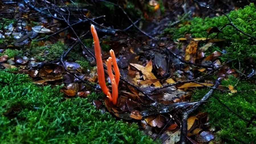
From the northern entrance the track has a short, slippery descent down into the rainforest where from this point onwards you follow a fairly straight and level track, which makes for very easy walking. At the bottom of the small hill I was already stopping to photograph fungi, an activity which easily added an extra hour to my trip. Not long after the start of the track I soon come across two creek crossings, one which had a nice wooden bridge and the other which once had a log bridge that was unfortunately washed about 60 degrees to the left so that it now leads directly into the middle of the creek. It was an easy jump across this creek though, but I soon realised once across that it might not be so easy on the way back… But oh well, onwards for now.

The track continues to follow Stephens Rivulet and there are a few points where you can stop and admire the sun poking through the treetops onto the water. I eventually came across a big pile up of small trees that had fallen over the track. This pileup was rather dense but I managed to climb through with some difficulty. I continued onwards, stopping every few minutes to photograph fungi, my favourite being a small green fungus growing on a fallen tree that looked like a smiling frog!


The track continued fairly flat with only a few ups and downs until I reached a large tree that had fallen over onto the track. I clambered over the tree and realised once on the other side that there was quite an easy way to go around it instead…
Not long after this tree, I walked out onto Blackwater 6 Road, which is the southern entry point for the Balfour Track. I wasn’t quite finished with walking at this point and as the rain seemed to had stopped for a while, I decided to head up Blackwater 6. I followed the spur uphill until I reached a large open muddy area to the right and a warning sign about an apiary site to the left. Now with the disturbing image of being attacked by a swarm of bees in the rainforest filling my mind, I headed further along the road, where clearly no vehicle had gone in a long time. The road very soon reached a fork, with a pink tag attached to a tree in the middle.
I decided I would wander down the left path, but I wasn’t feeling adventurous enough to continue after a point where the overgrowth became very dense. So I backtracked and headed down the right, only to find this road was similarly overgrown. However on the right path, a few pink tags led off to the right into the forest, which I followed for a short distance until no further tags could be seen.
I now know from that the path to the left is a trail described in Phill Pullinger’s Tarkine Trails book, however what lies at the end of the right path, or the marked route off the right of it remains a mystery. Attempting to follow any of these routes would require some good navigation skills as well as a GPS and map, as it is incredibly easy to get lost in dense rainforest like this.

I decided to head back and save exploring for a later day. Walking back was a much faster journey as I wasn’t stopping to photograph any more fungi. This time I walked around the large tree and crawled back through the pile of fallen trees until I reached the creek crossing I had quickly forgotten about and attempted the jump back, only to just miss and land in the murky water to discover the hard way that this creek was waist deep…
I climbed out, thankful that my phone was in my jacket pocket and that I had polyester pants on. I soon reached my car.
After this I drove further along Blackwater Road and onto Sumac Road to the Julius River picnic area, where I had lunch, before driving further onto the Lake Chisholm Forest Reserve. Lake Chisholm is a limestone sinkhole that filled with water over time. The lake is protected from all sides by forest and there are no streams running in or out of it. Because of this, it often sits perfectly still, making for some impressive reflections.
The weather was clear the entire time since leaving Balfour Track, only to pour down as soon as I pulled into the Lake Chisholm carpark. I decided to wait out the rain and it soon cleared up again so I grabbed my camera and headed along the short, clear cut track. The stillness of the lake and ambience of the forest made for a very peaceful atmosphere. You could easily spend hours here absorbing and admiring the beauty of this place.


The Balfour Track and Lake Chisholm walk are two accessible introductions to the beauty of the Tarkine. And given that there are countless areas of native forest that have been heavily logged all around this area, these walks are a great way to see just how threatened the Tarkine is and exactly why it needs to be protected.
There’s much more to be explored in this area and I’m sure I will be returning soon.
To reach the Northern entrance to the Balfour Track Follow Trowutta Road out of Smithton before turning right onto Roger River road which eventually becomes Sumac Road. When you cross the Kanunnah Bridge, turn right onto Blackwater road and approximately 4.6km’s from here you will see a large parking area to your right and the entrance to the track on your left. The Lake Chisholm Forest Reserve is a left turn from Kanunnah Bridge, following Sumac Road for 12km’s before turning left at the signposted Lake Chisholm Road and following it to the carpark.
